Mackenzie District Council supports and encourages operators of Unmanned Aerial Vehicle (UAV/'Drones') to familiarise with the Civil Aviation Rules governing UAV - Drone use.
The purpose is to ensure that aviation safety is maintained and drone operators are taking responsibility for ensuring the safety of their operations and of surrounding airspace.
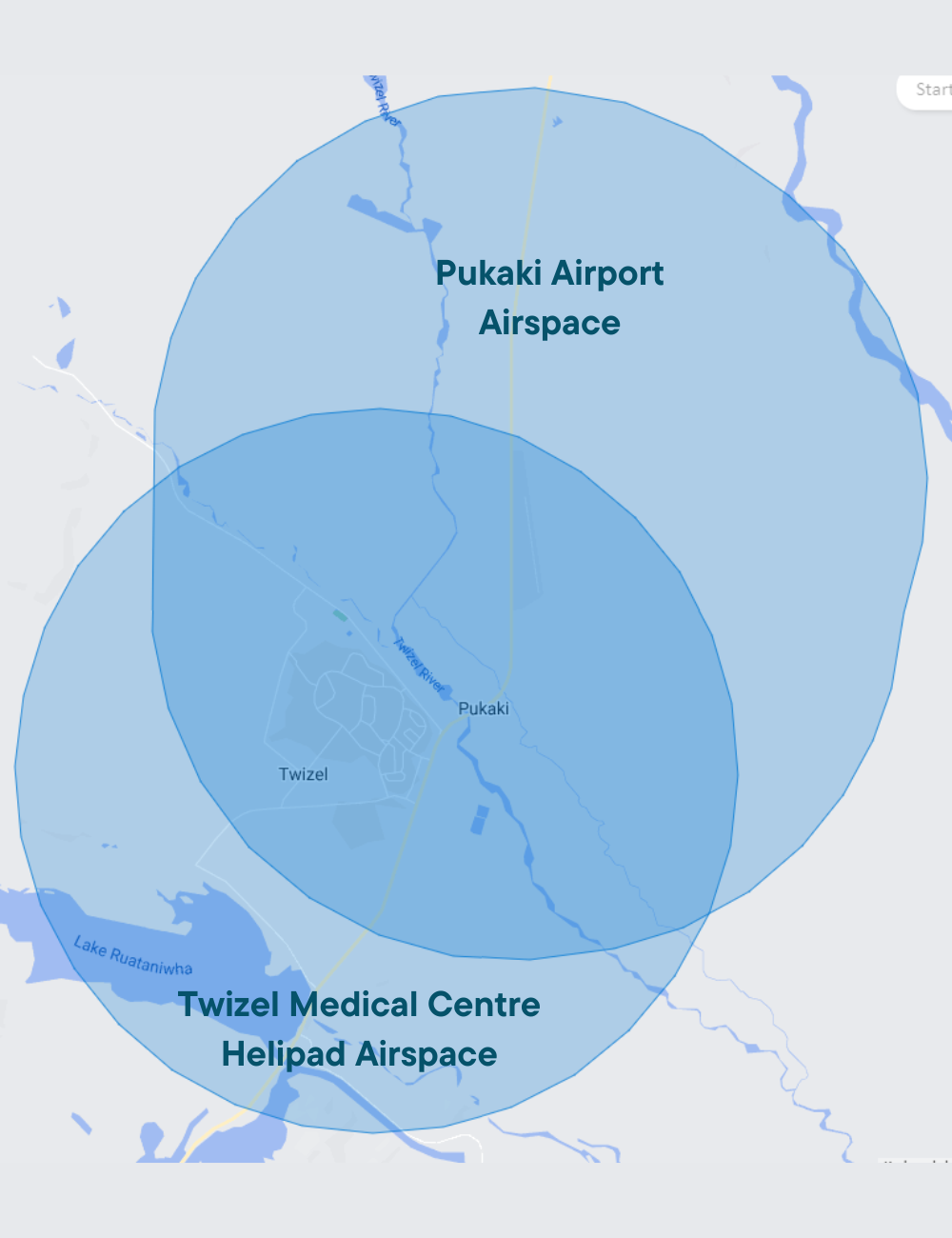
The rules include restrictions to flying UAV - Drones within a 4km radius of airports. Further information is available on the airshare.co.nz website.
![]() UAV/Drone operators are responsible for ensuring that their flights comply with Civil Aviation Rules.
UAV/Drone operators are responsible for ensuring that their flights comply with Civil Aviation Rules.
The Airshare website was developed to assist UAV/Drone operators to find the relevant information for flying drones correctly, and responsibly.
Airshare has been developed by Airways New Zealand in collaboration with Callaghan Innovation, Civil Aviation Authority (CAA) and the industry body UAVNZ, and is widely supported by the commercial UAV/Drone community and recreational flyers.
The use of UAVs/Drones in the Mackenzie District is guided by The Mackenzie District Council Policy on Flying Unmanned Aircraft 2015.
The Mackenzie District Council can only grant permission to fly a drone over Council Owned land. There is a blanket consent granted to fly on Council Land. However, in the following circumstances permission is required.
- Council offices
- Council land managed as plantation forest
- Council cemeteries
- Any council land that is leased to another party
- Any location on council land during an organised gathering of people (including sports events)
- Lake Alexandrina bach settlements
- Formed council roads
- Pukaki airport
- Playgrounds
- Water and sewer treatment plants and reservoirs
Lake Tekapo / Takapo
There is a ‘No Drone Zone’ within the Lake Tekapo. Please contact the Civil Aviation Authority for permission to fly a drone within this zone. Drones@caa.govt.nz
Lake Pukaki
The land surrounding Lake Pukaki (and the lake) is largely owned by Meridian Energy.
Aoraki Mount Cook
The land at Aoraki Mount Cook is administered by the Department of Conservation. All Drone use on conservation land requires a permit, for both recreational and commercial purposes. For more information, please see Drone use on conservation land: Apply for permits (doc.govt.nz).
State Highways
The Mackenzie District’s townships are connected through a series of State Highways. To fly a drone on, above, or beside a state highway please contact Waka Kotahi – New Zealand Transport Agency.
Circles indicate the 4km radius of Pukaki Airport, and the Twizel Medical Centre Helicopter Landing Pad.